|
|
Saturday, June 01, 2002
Have been unable to test joystick support (Melbourne). Unable to find a single, second-hand serial or USB port controller. Will look into options over this weekend in Brisbane. The next step is to look at sucking GPS data into GyPSey, followed by MIDI controller action. In the meantime, I'm looking into updating all available documentation.
posted by andrew garton
5:38 PM
Wednesday, May 08, 2002
Minor update - joystick support in, whap 'j' and the joystick can then be used to zoom around. Will not scurry to get the interface a little more substantial, now there's a few options, and also let the windows user resize/maximise/fullscreen the view...
posted by Chris Curtis
7:03 PM
Monday, May 06, 2002
With regards to visualisation, the present "neon-tube" style is more than adequate for now. In fact, the geographical boundries could be toggled on or off, as they could be considered contextually irrelevant when reviewing a personal track.What will be challenging, in terms of imagery, is the placement of anecdotal references (photos, videos) at marked waypoints that one can zoom into, view/play on request. Watch of update of specification :o).
posted by andrew garton
11:26 PM
Saturday, May 04, 2002
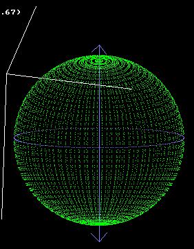
And another version, this time working on a new tier of options for the preview, wireframe mode.
Make sure earthframe.bmp is in the same dir as gypsy_win.exe, and press 'w' to switch modes.
posted by Chris Curtis
1:52 AM
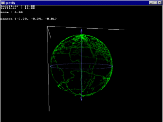
Minor update chucked in the files section - the version with some pov-ray output, creates gypsy.pov which is left in the current directory, only partial so far, being rehauled. This build doesn't try to call the renderer (mainly because I'm waiting 1/ for the release candidate version to finalise with pov, and 2/ work out the best way to deal with it, overlay it over the wireframe, showing in a second window, have a second window continually rendering).
Also mouse control is in - try zooming in and out with the mouse-wheel etc. Decided on a quake-style interface, mouse movement changes direction of camera, and arrow keys or mousewheel to move in/out/left/right. Have disabled joystick control... because Mark's asleep in his room and he's got the only joystick, so I can't test it :p Expect a tonne of updates starting from Sunday, have to go camping tomorrow till Sunday (fun fun fun), but there's a whole pile of things waiting to fall into place. By next week, I hope to have a version which will, given enough texture maps in the definition file, allow you to actually zoom in right from space, to Australia, to Queensland/Melbourne, down to your suburb, down to your street, house, and down to a blade of grass on your front lawn, if you've put all the textures into the date file, with a refresh rate of about 5 frames per second, at photographic quality on every frame, to arbitrary precision. Think, the view a skydiver would get, freefalling from space! The data setups for this will be something like, essentially just a collection of textures with the latitude and longitude of the top left, and bottom right corners, for scale. The hard part will be algorithms to select the right combination of visible textures, and sort them correctly. Maybe I'm just geeky, but I think this will be very well cool :D For screenshots of some renders done, should I just shove img tags in here, and link to jpegs placed in the gps folder?
posted by Chris Curtis
12:56 AM
Friday, May 03, 2002
Hello, I'm still alive :)
Well, I'm adding the finishing touches to another upload of the gps visualisation program, if not this arvo, then tonight, now I've finally got some time I'm going to bring in a whole new set of features, mainly in two areas. Firstly, and probably most excitedly, adding the rendering of tracks onto the surface of the globe. Any suggestions on how they should be visualised are welcome, I'm doing them as a fairly bog-standard sort of neon tube over the landscape. All goes well, they should be in 3d, ie, if you climb a mountain, and zoom in and tilt the axis, you should see the rise of your ascent and descent. Cool. Second area is the interface, this is not so much a to-do, as a how-to-do? There's a few different control-sets which are handy, the last build you guys saw let you change the lat-long and just focussed the camera accordingly. This would get blimmin messy if you started rotating the view... you can kind of see when it seems to spin sharply, or not at all, so, other ways are joystick-style panning (relative), rotating, shifting and zooming, something. I'll most likely end up just letting you flick between them. And to Justina, family was relieved to hear of your safe trip - email was printed out and given to mum. Fraid we have nothing like their telly. She's also promising to send a webcam 'allo' photo. Phwoar - technomum!
posted by Chris Curtis
4:55 PM
Saturday, April 27, 2002
Justina's in Manila from 21 - 28 April. On 26 April, she ventures out into Old Manila on a GSP pilgrimage tracking locations listed in Neal Stephenson's novel, Cryptonomicon.
posted by andrew garton
7:06 PM
Wednesday, April 17, 2002
Vector based mapping tools appear to be making inroads into domestic markets, particularly where wireless and PDA applications are of interest. Zoom a Map is one company developing "streaming techniques with industry standard vector graphics formats to enable publishers of location based wireless services to create applications for ease of use and portability."
posted by andrew garton
10:17 AM
|